Hurupaki Mountain was clear of trees when Maori constructed their large pa site there. They terraced the slopes to provide flat areas on which to build their houses. About 70 pits were built, most constructed as underground storage for the kumara and berries grown on the slopes of the hill; some of the shallow pits and terraces would have had whares built on them.
*Note – Some points on the map are in approximate placing due to not having an address.
The Maori chief, Pohe, had his pa on the mountain. He was the chief most of the area within the district known as Whangarei.
Hurupaki is a Māori word and means to cover with a cloak.
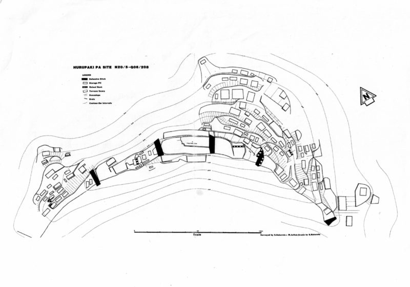
To view a larger copy, click here
1. The Brickworks
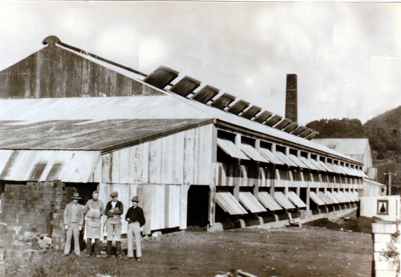
The brickworks date back to 1916. Two Dalmatian immigrants started the brickworks and produced ordinary building bricks.
When Kamo Potteries Ltd took over in 1921 they found that the type of clay available was most suitable for firebricks. By 1931 the works had expanded from domestic to industrial products and was manufacturing firebricks for cement works, the railways and the Navy. During World War II the company supplied the refractory bricks to the armed services in New Zealand and the Pacific Islands.
Clay for bricks and other commodities was obtained mainly from the hillside next to the factory and from Kauri Mountain. These clays were used to manufacture good quality, high-duty bricks. The factory also manufactured field drainage tiles, hollow ceramic building bricks, red building bricks and roman tiles.
The plant expanded in 1961 to produce a variety of firebricks and refractory products.
In 1966 the brickworks became Kamo Green Refractory Co and used technical and engineering services of a company in Missouri. The business wound down as the demand for bricks fell. In 1988 the land and building were taken over as a gardening centre known as Greenfingers.
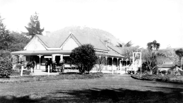
2. Kamo Springs Hotel (38 Great North Road)
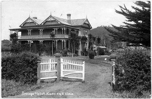
In 1889 James J. Taylor discovered mineral springs at Springs Flat.
The springs were opened to the public in 1894 when two baths were built as well as an accommodation house. By 1897 the facilities included a swimming pool and the Champagne Bath, named for the tingling sensation brought about by the gas bubbles.
In 1899 a company started the mineral and aerated water industry. Then a new company started up in 1900 to carry on the business of bottling, exporting and manufacturing the waters, as well as running the sanatorium, boarding house, hotel and baths.
The Kamo Springs Hotel was completed in 1902 but the accommodation house was converted into a sanatorium in 1901. In 1901, before the opening of the Kamo Springs Hotel. By then the complex included four natural pools and some artificially-heated private baths. The hotel was destroyed by fire in 1915.
Fumes from the mineral waters were dangerous in enclosed spaces and the gases had to be measured before the pools opened each day. About six people died after becoming overcome by the fumes during the years the spa was in use. The springs are now located beside and behind the large building on the site.
3. Kamo Sanatorium and Baths (38 Great North Road)
During World War 1 the sanatorium became an auxiliary hospital for troops invalided home. Fifty soldiers at a time were housed there. After the war it was adapted as a convalescence home for returned troops.
A decline in interest in spas led to closure in the mid-1930s. The sanatorium was turned into a tearooms and became the centre for an attractive recreation area with tennis courts and a large open-air swimming pool but by the late 1950s the spa was once again in decline. The pool is no longer in use and a large building used as a church has been built on top of it.
A camping ground was also established. It was open to the public and was popular during the summer months. The complex is on the north side of Excellere College.
4. The Roadside Spring (76 Great North Road)
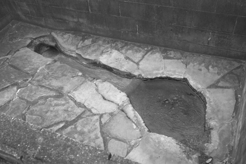
Kamo mineral water can still be obtained from this roadside spring.
5. The Brown Barn (37 Waipanga Road)
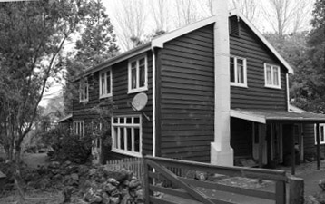
This house was originally used as a barn. It was built on the lower side of the railway line on Waipanga Road, in about 1900 to house draught horses, so, fittingly, chaff was stored in the top storey of the building.
In 1913 the Territorial forces in the military camp nearby used the barn to stable their horses. Later owners milked a small herd of cows in the barn.
Later still, in the 1960s, a Canadian carpenter and his family bought the barn and converted it into a living space.
6. The Government Forestry Nursery (Waipanga Road)
In 1903 a forestry nursery was established on 65 acres of the Onoke block fronting Ruatangata Road (now Pipiwai Road), with the southeast boundary next to the railway reserve and ballast pit. The land was planted in forest and the nursery was set up to supply seedlings to the Puhipuhi State Forest. The nursery closed in 1910.
The nursery community was centred around three four-bedroom cottages, the single men’s quarters and attached office, a stable block with four stalls and a workshop, a cart shed and lean-to, and a large double-storied building that housed a mossing shed. Next to the railway line at 52 Waipanga Road is one of the small houses which belonged to the Government Nursery.
Several mature cork oak trees (quercus suber) from the original nursery can be seen down the hill, on private land either side of the driveway at 59 Waipanga Road. They are large spreading trees with distinctive bark.
7. Onoke Ballast Pit (Dip Road)
The Onoke Ballast Pit is within the Onoke Scenic Reserve. Legal access is possible from Dip Road.
This pit opened around 1878 when work on the Whangarei-Kamo railway section of the railway began and was the site of critical importance to the development of New Zealand’s railway network; track ballast sourced from the quarry was used to form the beds upon which railway sleepers were laid.
The quarry had an incline connecting its face with the railway below. The reserve has been extensively modified by the quarrying operation.
To get scoria from the quarry face to the crushing plant, the trucks were pushed into a long tunnel called a chinaman*. There were two of them. Here the trucks, or skips, were filled by opening trapdoors in the tunnel roof and pushing the scoria down into the trucks. These were then trundled down to the hopper feeding the crusher. From the crusher, the scoria was loaded into the end tipping skip which, when full, was lowered down the incline by means of a long steel wire rope. As the full skip descended the rails an empty one was hauled to the top and the process repeated.
Although the quarry area has been cleared of machinery and the lines pulled up, it is possible to find a few bits and pieces among the undergrowth. The chinaman tunnels have collapsed and now look like long narrow cuttings or caves without roofs.
The quarry was closed in 1929.
- “Chinaman” was a term used to describe men from China who immigrated to New Zealand. Many came here in the late 1860s gold rush and then moved to other parts of the country to work in mines when the gold ran out. There was a panic about the number of Chinese immigrants that led to discriminatory legislation. While “Chinaman” is a literal translation into English of the Chinese term for “Chinese man/person”, 中国人 (Zhōngguó rén) = “China man/person”, it is now considered offensive by some due to the way it has been used as a pejorative.
8. Kinross (86 Bush Road)
Kinross was built about 1931 by Mr J A S McKay, who named the house after a county borough of Scotland. It is a blend of different styles: antique stained-glass windows can be found next to ranch sliders and a modern pot belly stove. The western verandah has been built-in and houses a spa pool, while the remaining verandah area has traditional fretwork and decoration.
9. Stonedale (368 Bush Road)
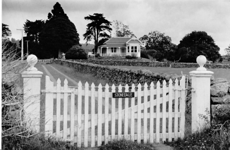
Stonedale was the home of Norman Howie and his sister Mary. Behind the house they set up a huge stone wall circle filled with dirt, where they would build a bonfire every Guy Fawkes night, which for many years all the locals would come along to.
The Howies had a talking parrot, which was well-known in the district. When the American army camp was next door during World War II, the parrot would often disrupt the soldiers training by calling out instructions opposite to the officer’s ordersd (like ‘turn left’ if the officer said ‘turn right’), from its cage on the front verandah.
10. The Wakelin-McDonald house (Elsie’s Way)
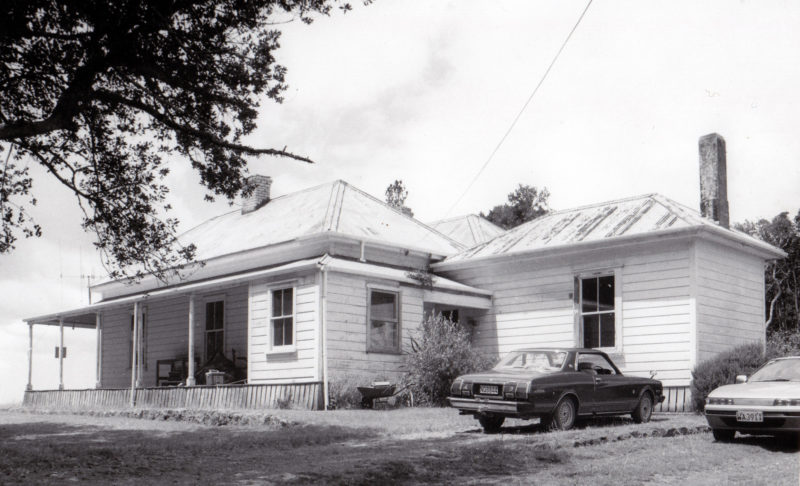
The Wakelin homestead was built by Frank Holman in 1875 for Thomas and Mary Wakelin. Arthur Wakelin’s sister Louisa lived there until 1949 when the property was inherited by her niece, Elsie McDonald.
Four acres of gardens surrounded the house. Local volcanic rock was used to build stone walls and to create ornamental edging round the carriageways. There was an oval in front of the house and a scalloped pathway leading to a sunken garden in the shape of a bell. The approach to the house was from Three Mile Bush Road, across land now accessed from Tuhangi Street and across the park to Te Paka Crescent and then to Fairway Drive and the homestead. A slightly raised, grassed-over carriageway can be seen crossing the park between Tuhangi Street and Te Paka Crescent.
The house is made of kauri. It has a full-length verandah along three sides. The rooms are spacious and have ceiling domes which may have been lit by chandeliers or lamps. Several of the rooms have large fireplaces and built-in furniture.
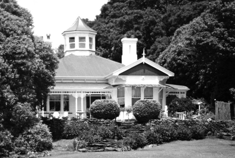
11. Moehau, place of sleeping wind (7 Tuatara Drive)
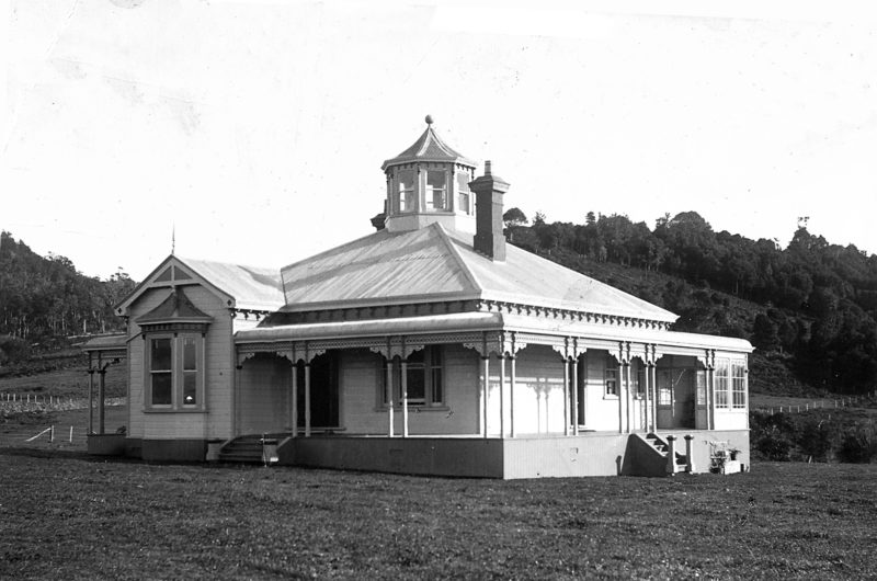
It was built for Dr and Mrs Richard Sissons in 1893. It originally stood in 27 acres of land, with gardens and an orchard, at the bottom of which was the Otapapa Stream. About 1956 it was subdivided leading to the formation of Tuatara Drive. The property has been reduced in size. Hodges Bridge once connected the house with the rest of the farm.
In 1927 the house was bequeathed to Mrs Johnson. It was then sold by auction to Mr and Mrs W P Hodge who subdivided it and named the Park. From 1957 the Mays, the Marshes, the Wales and the House families lived there. It is a spacious gabled house. It has a bay with a return verandah and elaborate fretwork. There is an attractive observation tower on top. It was the first turreted house to be built in Kamo. The tower has eight sides, a total of 16 windows and access from inside the house by two staircases. The house was designed to be lit by oil lamps, each room having a decorative central ceiling space which also served as a ventilator.
Registered with Heritage New Zealand.
12. Hodges Bridge (Stone Bridge Reserve)
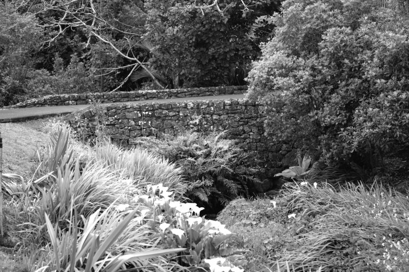
A stone bridge across the Otapapa stream linked Moehau with its orchard. It was built for Mrs Sissons by an English stonemason Thomas Cameron about 1894. It is made entirely from dressed natural stone fitted together to make a self-supporting arch. It is now part of Hodges Park.
The Swimming Pool (in the Recreation Ground)
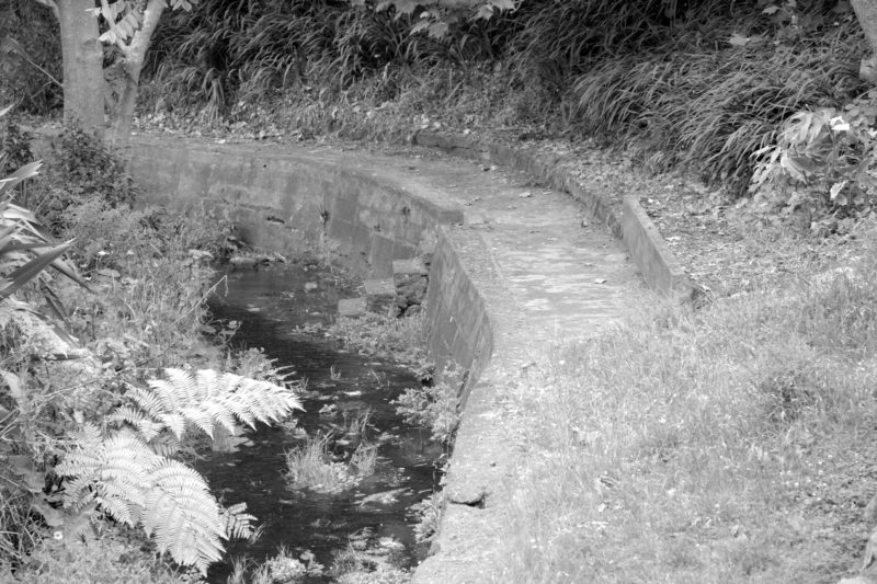
Started in 1931, an area called ‘The Bend’ used to be a popular swimming hole in the Otapapa Stream in Kamo. The stream was widened and deepened and the banks walled with concrete. Other gradual improvements made each year included concreting the bottom, building a dam at the top end and then adding seating, dressing sheds, and planting trees.
With the introduction of the primary school pool, the creek was abandoned.
Fact or Fiction
Local Truths
- Thomas Wakelin, a farm worker and butcher, became a cattle dealer and auctioneer, and built the first sale yards and the first hotel in Kamo. North Auckland Farmers ran competing sale yards, at the top end of Kamo, opposite Puriri Street. With two sale yards, Kamo was frequently invaded by mobs of cattle.
- At one time every railway engine in New Zealand was lined with Kamo bricks.
- Kamo had the first racecourse in the district. Meetings were run by the Kamo Racing Cub which closed in 1912 because of problems with bookmakers and its inability to run the totalisator.
- Gum diggers settled at Gumtown Road in 1880. The place was known as Rowdy Town or Gum Town until the early 1900s.
- During World War II there were at least four separate American and New Zealand army camps in Three Mile Bush, Kamo.
- Coal was discovered in Whauwhau Valley in the 1860s and a mine was developed. A wooden tramway was built from the mine to the Hatea River so that coal wagons, pulled by horses, could be loaded onto ships.
- At the end of Whau Valley Road is the principal water reservoir for Whangarei City, created by the Whau Valley Earth Dam.
- Rugby league was Kamo’s number one sport from 1928-1938.
- For many years the town boasted Northland’s strongest table tennis club.
- Gum diggers settled at Gumtown Road in 1880. The place was known as Rowdy Town or Gum Town until the early 1900s.
- Lake Ora, once called Lake Oara, means alive, well or satisfied with food. It was a rich food source in the early days when people used to camp for a week in the open down by the lake, eeling.
- The eels were dried for a food supply.
- Limonite, or bog iron, was mined from Springs Flat and Bush Road, where it formed hard, crumbly iron pans in swampy basins. It was used to filter gas in the gas works in Water Street, Whangarei and in Auckland, and also as a paint pigment.