KAMO is a Maori word meaning ‘eyelash’, or meanings associated with the eye such as ‘eyelid’, ‘wink’ or ‘blink’, but it has also been said to mean ‘to bubble up’, referring to the numerous springs that are scattered throughout the district.
According to Diana Menefy’s book, Kamo, the Story of a Village, there are several versions of the story about the naming of Kamo. “Some people say the main character was a man… but agree it was the puriri tree in Grant Street that still stands today.
A local chief, accompanied by some of his people, went away for a distant visit, leaving his wife at home. When the visit was over and they were travelling back he was overcome with the feeling that his wife wasn’t being true to him. When they stopped at a watering place he gazed into the water. There he saw reflected his wife’s image. She was naked under her cloak. Angry, he rushed on ahead of the party and on arriving home dealt with his wife’s family. He took her and hung her from the puriri tree. By the time the rest of the party came through she was almost dead, but she blinked. And that is how Kamo got its name.
That puriri tree still stands in Grant Street today.
NB Since writing the text for this brochure in early 2018 I have begun to doubt that Number 1 of this trail IS a crown hole subsidence and think that it may be a trough subsidence. I based some of the text on Tonkin and Taylor’s 2013 Report called Mine Subsidence Hazard. Since writing this, the area in question has been the subject of a new geotechnical report (2018), which I have not been able to access. A second subsidence was found next to the first and had to be dealt with. In 2017 a group from Kamo Community Inc. (of which I was a member) was planning a pocket park for this section, but when the subsidence was investigated and found to be more extensive than at first thought, the plan had to be abandoned. It would be sufficient to say that it is the site of a mine subsidence hazard. (Jane Painter 2019)
Google Map of Kamo Heritage Trail – Boswll Street – Town Centre
*Note – Some points on the map are in approximate placing due to not having an address.
1. Trough subsidence, corner of Grant St and Boswell St.
The corner of Grant and Boswell Streets was the site of a ventilation shaft about 27 metres deep in the Kamo mine. Large boulders and unsuitable mine refuse were tipped into the shaft and blockage resulted further down the shaft but the void below caused a collapse hole in the ground. When attempts to clear the blockage failed, the shaft was filled to the surface and capped with a concrete pad. This section has not been built on since the shaft was filled. The house on the adjoining section is within a few metres of the capping. New concrete in the driveway reveals where the drive subsided.
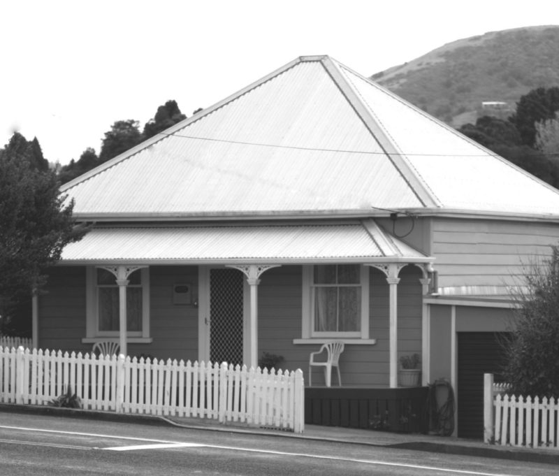
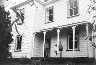
2. Miss Olive Smith’s House
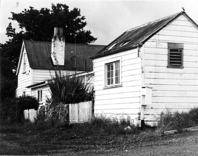
This two-storeyed colonial cottage was built before 1900. The Halse family’s great great grandmother Street lived in this house. From the 1930s Miss Olive Smith, a stalwart of the Salvation Army, lived here.
3. All Saints Church
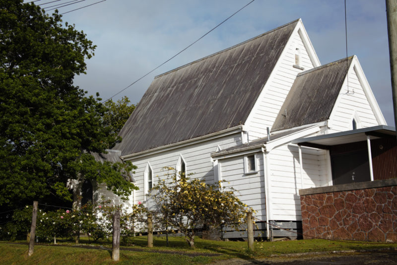
This former Anglican Church was dedicated in 1886. Mrs Sissons gifted a stained-glass window to the church in memory of her husband Dr Sissons. Mrs Sissons was organist for the church for 40 years. On her death she bequeathed her organ to the church. It was moved off its foundation by a hurricane in the 1950s, but was repaired and put back. The church has been a Christian Science church since 1958.
4. The Kamo Mine
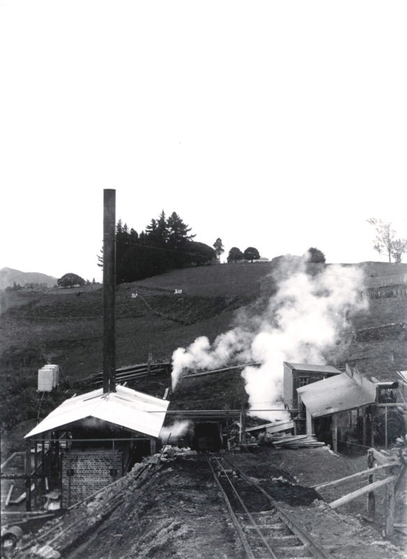
Coal was mined beneath Kamo almost continuously from 1876 until 1955. The New Kamo Collieries Ltd began near the Kamo Railway Station in 1934 over an extensive field of good quality coal. The mine worked towards Mt Denby, and surfaced near the present Kamo bypass.
The coal from the Kamo mine supplied various works in Northland. The mine was bought by the State in 1948. The mine output was 1200 tons a week. Up to 200 men were employed and underground roadways covered 30 miles. Production in 1950 was 57,000 tons. But in 1955 the mine was flooded. Water poured in so fast that it could not be contained by pumps and it was abandoned. It was officially closed in 1956. It was estimated that the mines still contain between three million and six million tons of coal.
The mine manager’s office was a small brick building situated at 33 Station Road next to the railway overbridge. Within the main office was a strong-room, which is still a feature of the house today.
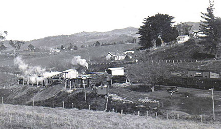
5. The Kamo Railway Station
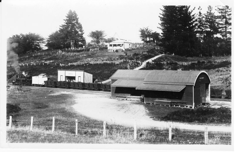
The Kamo railway station and goods shed, right, used to be directly below the east end of Grant Street. Trucks accessed it from the east side of the bridge over the railway line in Station Road. Trains were needed to carry bricks from the Kamo Brickworks and coal from the nearby Kamo mine. It was opened in 1880. Kamo to Waro was completed in 1894 and in stages to Kawakawa in 1911. The station and goods shed were erected in Kamo around 1883.
6 & 7. Two miners’ cottages – 32 Station Road and 28 Station Road
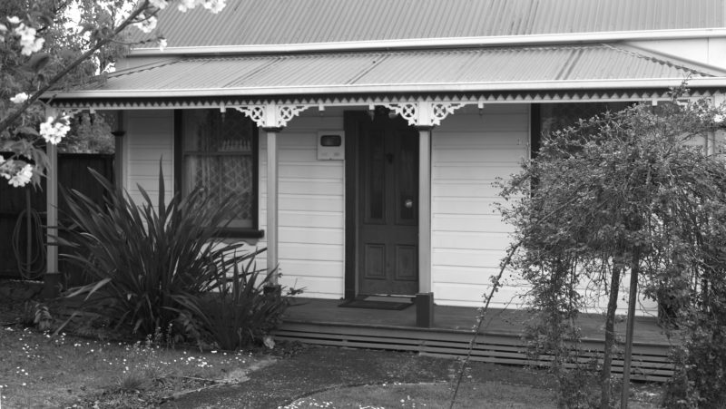
After coal was discovered accommodation was required for the influx of miners, and cottages such these were built. The small size, the rectangular shape, steep roof and lean-to at the back of the top house are features of very early NZ architecture but other features are of a style common during the 1880s and 90s.
The lower cottage was once number 4 Station Road. It belonged to Robert Whitelaw, the Town Clerk. The house would have been built in the late 1800s, from kauri and native timber from the area.
8. Kamo School & the oak trees

The first Kamo School started in a private house in 1873, moved into the Kamo Public Hall in 1877 and eventually to the old school building (where the present-day hall stands) in 1881.
In 1956 the old Kamo school building was dismantled.
A line of oak trees, now heritage trees, was planted on 4 August 1892, New Zealand’s first nationally celebrated Arbor Day. They marked the boundary of the original school and were planted by Miss A Tristram and two pupils.
9. The Schoolhouse behind the car park
This two-storeyed house was built in 1880. The first occupant was the Reverend Richard Coate, the headmaster from 1879 to 1884.
The house is very plain with only basic decorative curved pieces at the tops of the verandah posts. It has high kauri ceilings and large airy rooms. It was used at one stage as a boarding house for trainee teachers.
Registered with Heritage New Zealand
10. The Post Offices
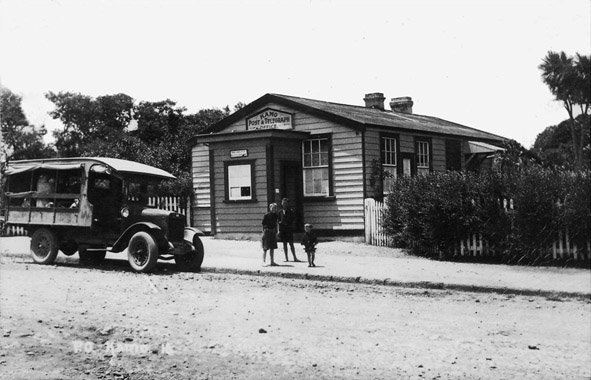
The first post office was along Station Road, 100 yards from the junction of Ruatangata and Bay of Islands roads. The combined telegraph office and post office was opened in 1881. In October 1937 a new post office building was opened on the corner of State Highway 1 and Station Road. The old post office was sold and a modern telephone exchange was built on the site.
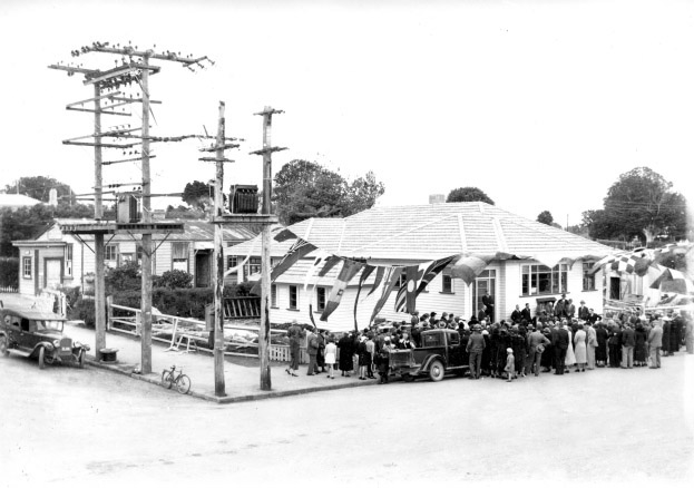
11. Kamo Town Board Office & Library
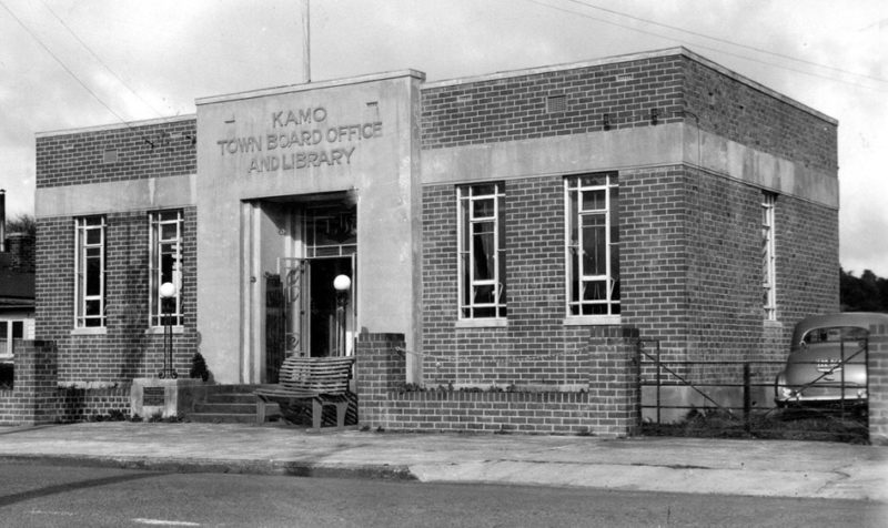
Kamo had its own Town Board until its merger with Whangarei in 1965. The Town Board Office and Library opened on 30 April 1938. The Town Board members laid many of Kamo’s footpaths themselves, organised street lighting and had the reservoir built in Dip Road for a regular water supply.
12. The Kamo Hotel
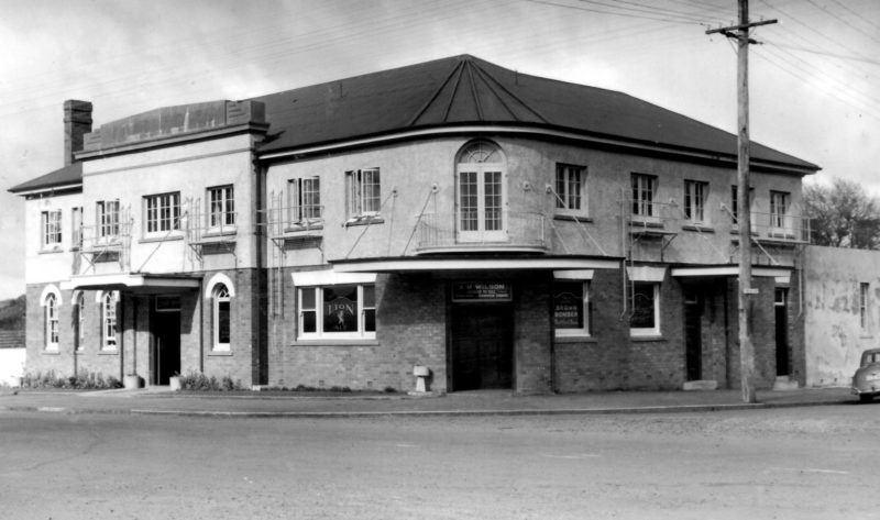
The first Kamo Hotel was built by 1880. It was destroyed by fire three years later and replaced. By 1885 The hotel was enlarged and additions were made to the top storey, to give 15 bedrooms. It then had a total of 24 rooms. The new hotel with a brick base began in 1937. The hotel was at its busiest during the mining era. The hotel was a magnet on sale days for stock agents, farmers and drovers. The hotel was also the army headquarters during World War II. The brigadiers used to stay at the hotel. There were a number of army camps in the Kamo area, both New Zealand and American. The hotel was a popular place for drovers who brought cattle for sale at the local saleyards, and for miners from the Kamo mine.
13. The Forge
Malcolm McInnes set up his smithy on the west side of Kamo Road, followed by his son Murdoch and later by Buller Crispin. The forge did well during the war when petrol was in short supply, but it closed in the early 1950s.
14. The Bakery…
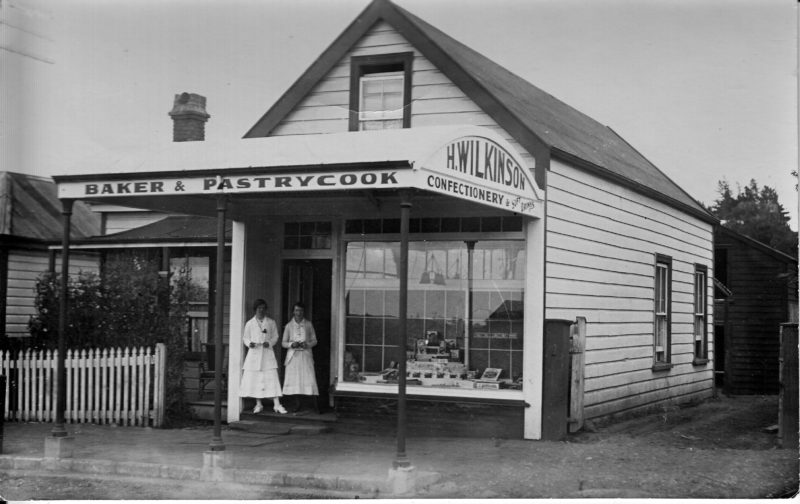
The bakery in Kamo had a succession of owners until it was bought by Harry Green Wilkinson in 1906. Harry’s son used to deliver bread in baskets around Kamo, but later on horseback, then in horse carts and motor delivery van. Electricity in 1922 took out the hard work of making bread. The original bakehouse had the shop at the front and the bakery at the back. After fires a new bakery was constructed where the present Hammer Hardware stands.
15.…and the Northern Motor Bus Company
The Northern Motor Bus Company was across the road from Wilkinson’s Bakery on the corner of Wakelin Street. In 1934 Arthur Wilkinson took over the company. Until he retired in 1972, he was the oldest holder of a passenger vehicle driver’s license in New Zealand. In 1928 he was the first man in Northland to drive a bus to Auckland and back in one day. He was also the first man to operate a bus service between Whangarei and Hikurangi, and to start sight-seeing trips around Northland. He was also first over the Brynderwyn Highway when it when it opened in 1938.
After the turn of the century Hardie Bros equipped a truck with seats and ran occasional trips from Whangarei to Kamo. A Mrs Mason started a Whangarei-Kamo service with a second-hand Ford bus. The business was such a success that she soon acquired a larger vehicle. Mr Harry Green Wilkinson entered the field in opposition and for a time there was a ‘transport war’. This ended with the amalgamation of the two interests to form the Northern Motor Bus Company.
16. The Lock Up
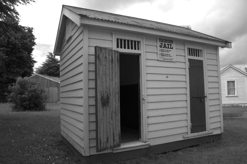
The jail was off Grant Street below Boswell Street in the centre of a paddock not far from the old Kamo Hall. It was two-cell wooden building. It had good use in earlier times when the Kamo mines were in full swing. This station was closed in the 1920s and remained unused until 1948 when it was moved to Kaikohe. There it was used as a cell block until 1967.
According to the Holman manuscripts, the policeman, Paddy Burke, had the distinction and the humiliation of being locked up in his own jail on one occasion. He had somehow offended a bunch of miners and they mobbed him, took his keys, marched him to his own lockup and thrust him in. They gave the keys to his wife.
It was acquired by the Kaikohe Pioneer Village Museum Complex in October 1976 and is now preserved in its original state.
Fact or Fiction
Local Truths
- In the area of the Kamo bypass just south-east of Kamo Intermediate School, significant evidence of early Maori settlement was discovered in 2011. Archaeologists found hangi pits, fire scoops, post holes and stone mounds dating back to around 1230-1275 A.D
- With its rich volcanic soils, abundance of spring water and favourable climate Kamo was extensively utilised for gardening by Maori in pre-European and early European times.
- The first white settlers in Kamo were Alexander Meldrum and William Carruth in 1856. Meldrum took the eastern section where coal was later found. Carruth took the western section.
- Once the road was formed a horse bus left Kamo for Whangarei at 11 am each day. A bugle was sounded to let everyone know that the bus was about to depart.
- Whenever a cutter arrived from Auckland the flag was raised on the flagpole at the corner of Wilkinson’s Avenue. It was also hoisted when the butcher killed fresh meat.
- Railway lines were laid and trains were running in 1880.
- The Kamo Methodist Church was built and dedicated in 1881 in Grant Street and a newspaper started the same year.
- In 1910 the Kamo Town Board organised street lighting consisting of four acetylene gas lamps on iron standards.
- In 1922 electricity, supplied from the Upper Wairua River Falls, came to Kamo.
- Traffic lights were installed in Kamo in 1972. They were the northernmost traffic lights in New Zealand until recently.
- At one time Kamo had three hotels – the Exchange, the Kamo Hotel (destroyed by fire in 1906, rebuilt and razed again in 1936), and the Star.