The closing of the Onerahi Railway and dismantling of the wharf in 1933, as well as WW2 marked a significant change in the character of Onerahi. The development of the airport in 1937-38 required the relocation of the school, the Domain sports fields, and some houses. It also gutted the Onerahi township which was then focussed around Domain Road. As a result in the late 1940s and early 1950s, to cater for a growing population, new subdivisions and a shopping centre were developed in the Sherwood Rise area.
Google Map of Onerahi Heritage Trail
*Note – Some points on the map are in approximate placing due to not having an address.
1) Boswell’s Track / Waimahanga Walkway
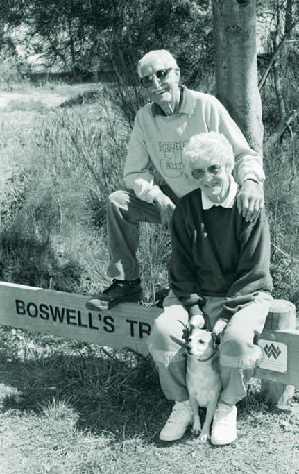
The Whangārei – Grahamtown (Onerahi) rail line was abandoned in 1937 with the rails removed and the Gull Roost Bridge demolished. In 1980 the Whangārei City Council authorised the clearance of scrub and gorse that covered the old line route.Jim Boswell, a nearby resident decided that the track needed ‘beautifying’ and with his wife Beryl and other keen supporters, planted an initial 150 gum, flame and pohutukawa trees. (Jim started this when he was 80 years of age). The naming of this section of the Waimahanga Walkway as Boswell’s Track is a memorial to community and environmentally minded Onerahi residents Jim and Beryl Boswell.
2) Gull Roost Bridge
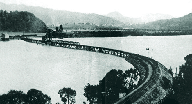
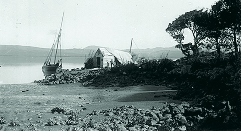
During the 1890s petitions to extend a surveyed railway line from Opau Wharf at Kioreroa to deep water at Grahamtown were presented to Parliament. By 1902 the Public Works Department began work at Opau and built a 970 ft wooden bridge with a 30 ft draw span. By mid 1911 the completed line, Gull Roost, wharf and station buildings at Onerahi were handed over to the Railway Department. The railway was closed on 1 July 1933, and the causeway and Gull Roost were demolished after the wharf and buildings were removed to Kioreroa. The Gull Roost connected to the Waimahanga Track 300m north of the George Point Footbridge.
3) Chert Workshop
In the intertidal area near the end of Raumati Crescent is the oldest ‘manufacturing’ archaeological site in Whangārei. The area contains chert, a sedimentary rock with high concentrations of silica. Māori discovered that it could be quarried and flaked to create tools for cutting, scraping and making drill points. The remnants of the chert quarry is a recorded archaeological site and is protected by law.
4) Raurimu Avenue School
Raurimu Avenue School opened in 1967. Originally named Onerahi South West School, it received its current name in September that year. Raurimu relates to the boat captained by Cecilia Perkinson and the school was built on land previously owned by her family.
5) Ki o Rahi
Ki o Rahi is a traditional Māori game based on the legend of Rahitutakahina and the rescue of his wife Tiarakurapakewai. Played by Māori soldiers in WW2, the large team game is still played in countries such as France and Italy and is experiencing a revival in NZ. In 2016, the Onerahi Resource Centre Trust led a community project to build a Ki o Rahi field and natural playscape on an undeveloped council reserve in Raurimu Avenue. Today this is the first fully carved Ki o Rahi field in Whangārei.
6) Eucalyptus Trees
Towering Sydney Blue Gum (Eucalyptus saligna) trees mark the route of the shared path from near the Pah Road roundabout for about 500 metres. When rail tracks were laid, the Railways Department often planted eucalypts alongside them as a ready source of timber for replacement sleepers.
7) Onerahi Pa
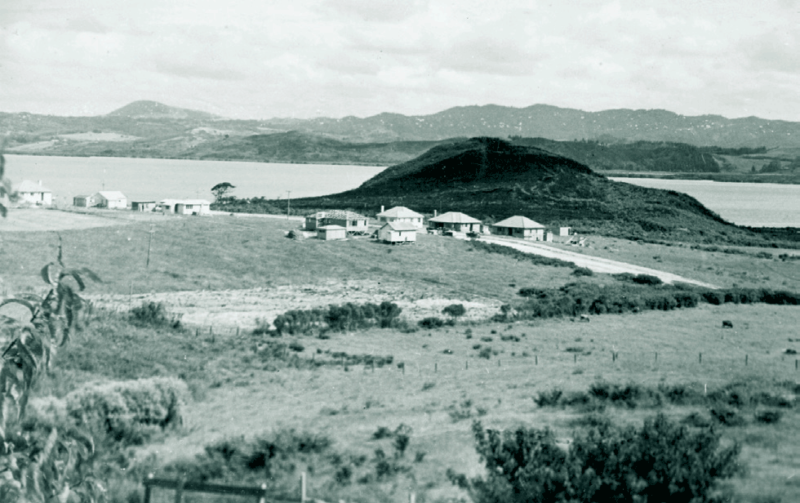
An important pa in the Whangārei Harbour area once stood on this site. It is believed to have been densely populated by descendants of Manaia, a paramount chief who reigned in the area. The population decreased through tribal wars and eventually Parihaka Pa became more important than Onerahi Pa. Originally the pa was approximately 6 metres above the current height of this area. In 1964 the top of the pa was removed and the spoil used to extend the runway. In 1968 Whangārei City Council approved the development of a marae on this site, however permission for a full marae complex was later refused by the Minister of Lands.
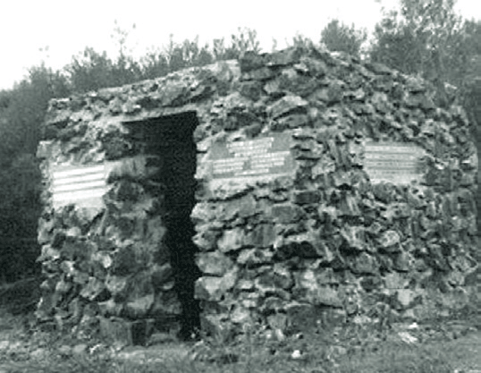
8) Kaiwaka Cairn
The cairn adjoining the foreshore at Kaiwaka Point is a poignant reminder of the first shipping vessel to run aground at this location. The Huon Belle, a 42 tonne schooner carrying a cargo of coal struck a sunken log at this location on 27 April 1897. All lives and coal were saved. A cairn structure was subsequently built and completed in 1925 to create a lighthouse to house a gas lit beacon.The structure was also known as a ‘spark plug’ and several of these were located in the Whangārei Harbour. This section of Beach Road was developed after 1937 on the original Onerahi rail formation.
9) Rotten Row
When the aerodrome was started in 1937, about 18 houses were relocated. Eight were situated on the north side of Handforth Street (now numbers 40, 42, 44, 48, 50, 54, the former 56), and two on the corner at 76 and 78 Church Street. These houses were nicknamed ‘Rotten Row.’ The remaining houses were relocated to the Stevens Point area and used as holiday baches.
10) Airport
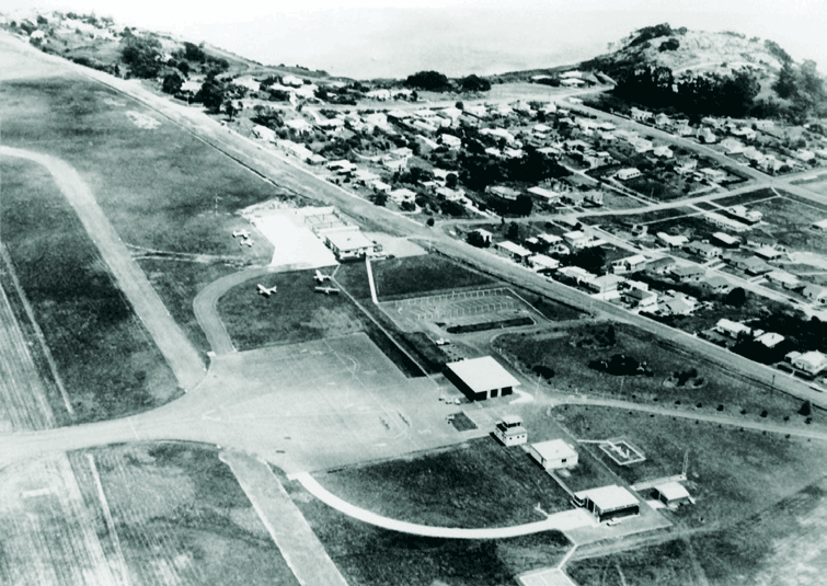
The airport was constructed in 1937-38. The first terminal was in a house that was located on the south side of the airport in Airport Place (now Whimp Avenue). The expansion of the airport in 1963 saw the terminal relocated to its current position. This second terminal was also in a house which was replaced by the present terminal about 1970. In 2016 the terminal was expanded and upgraded.
11) Onerahi Lookout
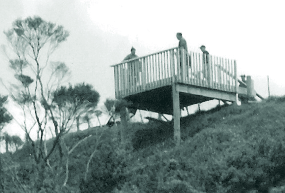
The original viewing platform was built by the Onerahi charter of the Lions Club in 1996 and then dismantled and later rebuilt on Matakohe/Limestone Island in 2006. The Onerahi Lions also built the current lookout which was completed in 2005. A plaque acknowledges funding donated by the Onerahi Amateur Theatrical Society when that club folded in the 1980s.
12) Wai-a-Ariki Food Forest
Council provided support and approval for a community garden and orchard to be developed in 2015 on land adjoining the Waiariki Stream. Volunteers have created the food forest with donations of plants and knowledge of multi-cultural planting practices.
13) Northland Sweet Factory
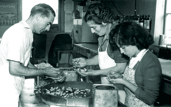
Ray and Doris Cockfield moved to 1 Whimp Avenue in 1946 and soon afterwards Ray started Northland Sweets. After several years he doubled the factory and employed two local girls. Sweets made included peanut toffee, acid drops, peppermint sticks, hokey pokey and Easter eggs. Up to four tons of sugar a month was used until the Auckland Wharf strikes in 1951 hence no sugar. Sweet making for St Stephen’s Gala Daycontinued until Ray’s death in 1988. Eventually the original building was converted into a garage.
14) Trout Hatchery
In June 1932 a trout hatchery was moved from Maunu to a site over the stream at (now) 36- 38 WhangāreiHeads Road. By August 1932, approximately 100,000 trout were ready for release. Under the care of Mr PJ McIlvride numbers grew and 600,000 fingerlings were released throughout Northland in 1938. However in December that year 80,000 fingerlings were found dead in the ponds. Although poison was suspected no cause was found for the deaths. The hatchery finally closed about 1950. At its peak over 750,000 trout were being hatched each year.
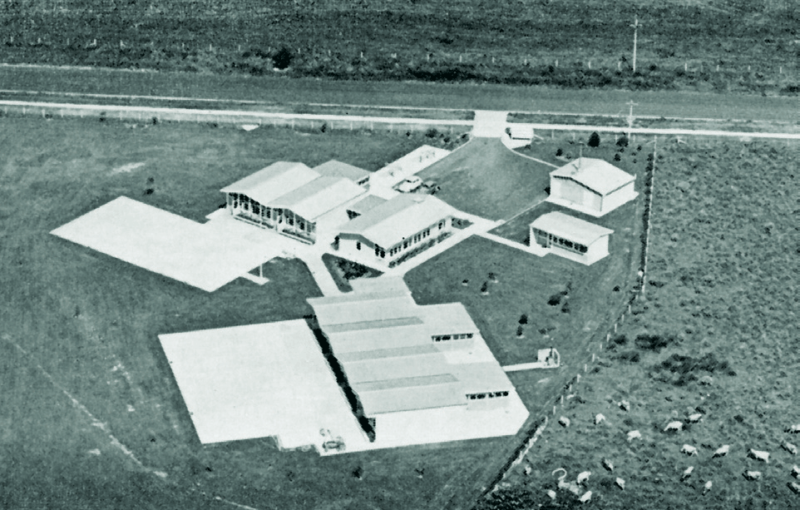
15) St Mary’s Hospital
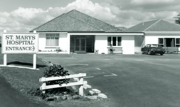
St Mary’s Hospital was built in 1953 on five acres of land. Originally called Onerahi
Private Hospital, it was renamed St Mary’s Hospital in 1963 following purchase by the Sisters of Mercy of Auckland. In the 37 years that the Sisters ran the hospital it expanded from 18 beds and one operating theatre to 30 beds and a new two-theatre/recovery room suite and day-stay room in the 1980s. In November 2000, the ownership of the hospital passed over to Primecare Services and surgical services were transferred to Kensington Hospital.
16) Onerahi Cemetery
Commissioners were appointed in 1897 to manage a proposed cemetery for Onerahi but it was some time before it was established. In 1910 the Trustees resigned and management was assumed by the Whangārei County Council. With the formation of the Onerahi Town Board in 1913 control was passed on to them and in 1959 with the amalgamation with the Whangārei City Council that became the controlling body. The oldest existing headstone is that of John Going who was buried in 1906.
17) Air Force Base Pine Park Road
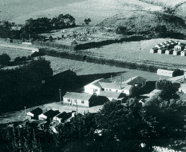
During WW2 an Air Force base was located at Pine Park Road and was surrounded by large pine trees. The area was L-shaped and the back corner extended into the present Onerahi Primary School grounds. At road level was the cook-house, dining hall, recreation hall and
medical centre. Down the left boundary there were one or two huts for officers and sergeants and along the back boundary area were huts for the other ranks. The airfield was one mile from the camp.
18) Onerahi School and Playcentre
The relocation of the Onerahi Primary School from its original site on current airport land, began in 1954 with the opening of two classrooms on the present site. It was not until 1961 that all the classrooms were built and the old school site closed. The Playcentre was formed in 1952 and met in the Onerahi Town Hall in Domain Road. With the expansion of the airport and the demolition of the hall a new location was needed and the building on the present site was erected in 1967.
19) Community Hall and House
The community hall is the third public hall in Onerahi. The Catholic Church owned land in Cypress Gardens Place and built St Michael’s Hall which was intended to be two classrooms. When the Town Hall in Domain Road was condemned for public use, this hall became the replacement venue for larger functions. St Michael’s Hall was sold to the Whangārei City Council in the early 1970s and moved to its present site on Sherwood Park. The Onerahi Community House was established in 1978 when local residents approached Council to have a house sited in Goodwin Street moved on to Sherwood Park as a place where people in the community could meet for friendship, coffee, support and learning new skills.
20) Onerahi Shopping Centre
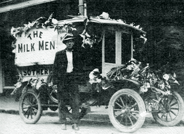
Sherwood Rise Shopping Centre, was built in the early 1950s. Approximately 1,200 people were living in Onerahi at that time. The first business was Sothern’s Dairy started by Ernie Sothern the local milkman. Others that followed included the IGA Grocer, Walker’s Fruit Shop, Shipman’s Butchery, Owen Wright’s Stationers, Haddon Simpkin’s Chemist, and Bowers and Knight Hardware. Later additions included a drapery, ladies fashion shop, a hardware shop and another butcher’s shop.
21) Dragonfly Springs
Work on developing Dragonfly Springs Wetland Sanctuary began in 2007 on land that had previously been approved for a 73 house subdivision. Formerly part of Hodgson’s peach orchard and farm, a stone wall made by Joseph Hodgson in the late 1920s can still be seen.
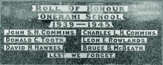
22) Commins Road Bus Shelter
In 1948 Onerahi resident Flora Commins erected a war memorial bus shelter built of stone opposite the Onerahi shops. It incorporated a granite tablet to commemorate the loss of her sons, John and Charles and four other local men who died during WW2. The shelter was demolished in 1972 and the road was later realigned. The memorial tablet is now located at Onerahi Primary School where the pupils hold a service each ANZAC day.
23) Golf Club

The Onerahi Golf Club was established in the 1950s with an entrance off Cartwright Road. It consisted of nine holes on a 27-acre site, and a one room hut that served as clubrooms. The club prospered, and in 1967 a new venue was needed. As no suitable land was available in the vicinity, the club purchased 110 acres at Maunu where the Sherwood Park Golf Club opened in 1970.The land was later purchased by the Education Department for a high school in Onerahi and has since been sold and subdivided for housing.